Category Archives: Local Issues

Collected here are campaigns, consultations and local issues we seek progress with.

Gilligan says Hammersmith Broadway is being reviewed by Transport for London

Today at the London Assembly the Transport Committee was talking to Andrew Gilligan, the Mayor’s Cycling Commissioner along with Ben Plowden of Transport for London and representatives of the LCC, British Cycling and Serco (London bike hire contractor).

Much of the discussion focussed on superhighways, HGV safety and other issues well aired in the media but saw some progress. There was particular questioning on junctions from Darren Johnson which focussed on the number of junctions and the ability of Transport for London to effect changes. Transport for London first committed to review 500 junctions (375 on superhighways) then refined that to a list of 100. Neither of these lists featured Hammersmith Broadway, which given the dangers and block it presents was a surprise. However, we are particularly drawn to statements made by Gilligan and Plowden after a query raised by Murad Qureshi about the gyratory or one-way systems at Hammersmith Broadway and Earl’s Court.

Murad Qureshi: There are a number of junctions that haven’t been mentioned particularly in West London that I am concerned about and some of them are huge gyratories, like the Hammersmith gyratory, Earl’s court gyratory. I’m sure there are cyclist concerns with those, so I would like an update of what you’re proposing there.

Andrew Gilligan: Hammersmith is on the list. It’s one of the 33. It’s a huge junction. It’s going to be a lot of money to make it genuinely unthreatening for cyclists. But it is necessary because there is no way around it.

On Earl’s Court, Ben Plowden stated that the rebuilding of the area would have to take cycling into account from the very beginning.

Pressed for time the committee moved on but Gilligan made a final comment that “[fixing] Hammersmith Broadway is the key to the whole borough”.

We were aware of conversations to discuss this, but this sounds like a firm commitment that change is finally coming and which recognises the problem this junction poses. We look forward to seeing a proposal and hope to see a comprehensive change to the junction to make it truly cycle friendly. We note the concerns of the wider campaign that earlier junction reviews have been compromised by modelling and hope that genuinely safe space is also advantageous and beneficial to people cycling and walking through or accross this dangerous junction.

Putney Bridge – Refurbishment imminent but mind the funding Pinch Point!

Our neighbouring borough of Wandsworth have recently won funding from the Department for Transport “pinch point” fund to repair Putney Bridge (they look after the whole bridge). It may not be readily apparent but due to water egress from a broken pipe into the structure some years ago the bridge is in need of drastic repairs. It is abundantly clear to anyone who cycles over the bridge that the carriageway itself is heavily deformed thanks to years of heavy vehicles especially buses squeezing dips in the surface. For those on a bike trying to hold a predictable or safe line over the bridge is a feat accomplished with some practice.

Funds were awarded to Wandsworth Council in May after a successful bid, but it was only last month in November that details of how the works might proceed were made public via a council paper advising on the options for construction. Intriguingly the timing proposed in the original bid was for construction to have started in August and be complete by February, clearly that did not happen!

Currently there are two options proposed:

  • 6 month full bridge closure, with at least one of the walkways kept open, cyclists could pass if they dismounted but it may be crowded at peak times
  • 11 month partial bridge closure, with at least one of the walkways open and a single lane kept open for buses and cyclists, with shuttle (alternate) working along that single 3m wide lane.

There are a few additional constraints. The Department for Transport require that their funding is spent by March 2015 (before the next Westminster government), and RideLondon is set to use Putney Bridge again in August 2014. Also, Wandsworth believe the 11 month closure would cost an extra £0.35m which they don’t currently have, so they can only afford the 6 month option. It does sound rather like the 6 month full closure is the likely option.

The 6 month option is proposed to start in June 2014 and complete in early December 2014, which presumes RideLondon 2014 will go via a different route. The 11 month option would need to commence by April 2014 at the latest to meet the DfT’s March 2015 funding deadline.

In the document for Wandsworth their officials stated:

The neighbouring London Borough of Hammersmith & Fulham support the [6 month] full bridge closure option as this enables an early start to their proposed highway maintenance programme for Hammersmith Bridge.

However, in a somewhat contrasting move Hammersmith and Fulham council this week published a news piece where leader of Hammersmith and Fulham council Nicholas Botterill said closing the bridge entirely would be a “disaster” and further said:

The main routes into and out of our borough are incredibly busy with huge volumes of traffic, notably the road connecting Fulham with Putney and if the bridge were to shut completely for six months that would be a disaster. It would cause a terrible knock-on effect for the rest of the entire borough, both on our roads and on our already jammed tube trains. While we understand this work must be done we want to see it happen over 11 months, which would cause less disruption for our borough, residents and people who work in H&F.

We should note that probably doesn’t mean the council leader in Hammersmith and Fulham changed his mind, or even that he disagreed with his officials. But we have Wandsworth and Hammersmith & Fulham council reaching opposite conclusions. Does their reasoning stand up when scrutinised?

Let’s get our understanding of the traffic right first, here’s a table of traffic over Chiswick, Hammersmith, Putney and Wandsworth Bridges. Figures in the Wandsworth council document do not include cycle figures, which is surprising. We’ve used the DfT traffic count data for this (points 6902, 8472, 73573 and 58200 respectively) northbound over the day. As it’s not robust for cycling we’ve averaged the past three years data.

Chiswick Hammersmith Putney Wandsworth
Cycles  261  1,236  2,277  1,401
P2Ws  1,498  1,218  2,283  1,104
Cars  28,668  18,857  34,104  29,815
Buses  376  1,464  1,656  915
LGVs  4,098  2,874  4,078  5,915
HGVs  1,319  215  1,049  1,049

A huge proportion of these cyclists will go over in the morning peak – we counted over 400 between 8AM and 9AM over Hammersmith Bridge in late October.

Wandsworth comment only on the effect on traffic over Wandsworth Bridge for which they say TfL predict:

a 17% increase in southbound traffic in the morning peak with no effect on northbound flow; and 27% increase in northbound traffic in the evening peak and a 3% increase in the southbound flow.

The message from the TfL modelling appears to be: congestion is so heavy at peak in the main direction of flow that almost no extra motor vehicles would be able to pass over Wandsworth Bridge. Apparently TfL believe Hammersmith and Chiswick Bridges will take the majority of the displaced traffic. It does not appear that TfL have modelled any impacts on cycling.

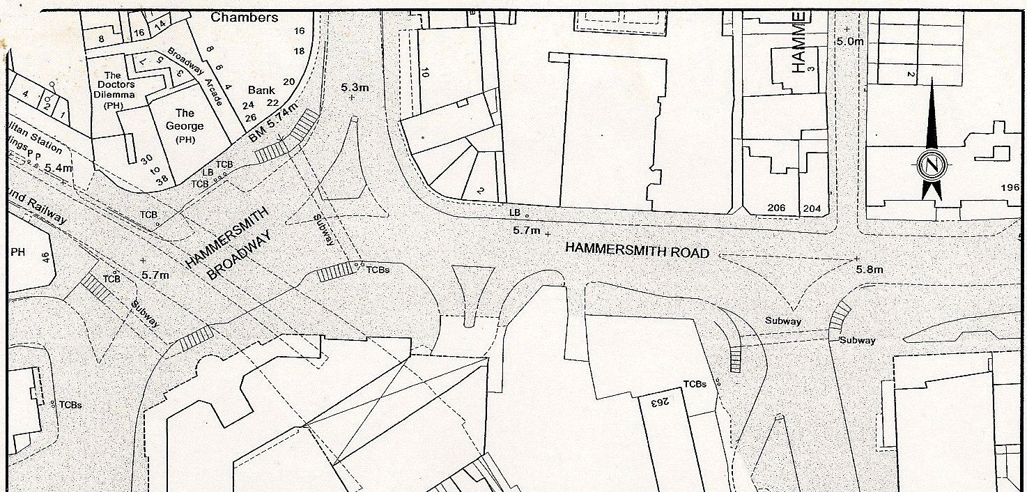
Chiswick Bridge’s approaches are poor, but the pavements are cycleable which is in part why so few cyclists over that bridge will appear in DfT data. What is striking is that Putney clearly has a large number of cyclists compared to the other bridges and the question is will they ride to the bridge and dismount or take another route?  Let’s look at the map of the area.

[osm_map lat=”51.475″ long=”-0.211″ zoom=”13″ width=”600″ height=”450″ marker=”51.46683,-0.21315″ marker_name=”bicycling.png”]

There are quite a few alternate routes in the area, but clearly the west side of Fulham will be hardest to reach via them. If Hammersmith and Fulham council’s now preferred option of 11 months closure occurs that surely means an extra 5 months of disruption on local streets. Over the bridge there would be easier transit by bus and bicycle, but to reach it you would have to negotiate some congestion presuming the dire predictions of Cllr Nicholas Botterill come true.

But maybe a large number of journeys will evaporate, as happened when Hammersmith Bridge closed during the late 1990s. In that context consider this statement about the effect of the closure of Putney Bridge on Putney High Street in the Wandsworth council paper:

much of the traffic on Putney High Street is through traffic and the closure of the Bridge to facilitate these essential works is likely to create a quieter less heavily trafficked and polluted High Street more attractive to pedestrians and shoppers

It will be interesting to visit Putney High Street during whichever closure occurs and see how the removal of through traffic affects it. Putney High Street breached annual emissions for NO2 in January, barely more than a week into the year. If much of the traffic that helps cause that is through traffic then it must either be coming to or from Hammersmith and Fulham or through it as well.

Hammersmith and Fulham council have repeatedly said they believe cycling can help combat congestion, if they think this closure risks it they could embrace cycling to help.  It is a pity that Wandsworth don’t identify any measures they would take to manage congestion and encourage other modes of transport. Perhaps Hammersmith and Fulham could suggest some measures, and seek supportive funding for them? Perhaps more use could be made of the quiet cycle route parallel to Fulham Palace Road and of the imminent Hire Bike scheme?

There is a consultation to which responses can be sent now detailed in the Hammersmith and Fulham Council news piece. We are considering the effects before submitting our response and welcome a discussion in the comments below.

Of course once this is complete things can return to normal, or perhaps better than normal if you help us analyse local barriers to cycling. And of course, Hammersmith Bridge is set for it’s own closure for repairs in the coming years.

Tell us about barriers to cycling in your area

space for cycling

As part of our campaign towards the local elections next year in May, we are asking everyone to take some time to look at the areas of London they know and how they might change them to make them and make cycling more pleasant.

There are six key themes or questions we’d ask you to think about:

  • Is there a main road or major junction that needs protected lanes?
  • Do your local schools have safe cycling routes for children?
  • Would your neighbourhood benefit from a 20mph speed limit?
  • Is your residential street used as a rat-run by motorists?
  • Is riding through your local town centre a total nightmare?
  • Does your local park or green space need more cycle paths?

We have a survey for you to complete to let us know where you would like to see changes. We will then collate these responses and through a meeting likely in January but perhaps February we will focus in on particular issues and combine your responses to create our local demands. These will be put to local candidates throughout London next year.

Obviously we would like people to focus on Hammersmith and Fulham, but most people’s experience will range over more than just this borough. Choose where you feel is most important. It doesn’t matter if you cycle a lot, barely at all or never – what we want is to know what concerns you.

There is an overview of the themes available for all of London which you may find useful. To give some local context, here’s a quick overview of the status of Hammersmith and Fulham on each of the themes, these may help you if you aren’t sure of the kind of things each theme or question is thinking of.

Is there a main road or major junction that needs protected lanes?
There is some protected space on King Street for the contraflow cycle lane, and there are the (shared) paths inside Shepherd’s Bush Green. By protected we mean a lane separated such that no mishap might easily lead to conflict with motor vehicles, usually protected by a kerb or other separation. No major road in the borough currently has protected space on it as part of a major through route. As to major junctions, the gyratories at Shepherd’s Bush Green and Hammersmith Broadway loom large, but even a T-junction can be dangerous with the wrong design.
Do your local schools have safe cycling routes for children?
Given that the main roads haven’t been dealt with as above, this is a problem. The council has placed a bid for a project to link 7 schools around Wormholt Park. This is relatively cheap (£180,000) but could be successful and could be repeated. We have written up details of it in our overview of the funding bid for next year
Would your neighbourhood benefit from a 20mph speed limit?
Note that 20mph limits are distinct from zones. A limit requires no specific traffic calming to self-enforce it, but rather signage and awareness. Police are moving towards enforcing 20mph zones. There is a map of 20mph areas in the borough on the council website which is mostly up to date, which shows school locations.
Is your residential street used as a rat-run by motorists?
There are a limited number of locations in the borough where restrictions have been used to reduce through traffic. There are many locations such as Trussley Road where narrow quieter streets remain used as through routes which can even totally block the road for cycling.
Is riding through your local town centre a total nightmare?
We have three town centres in the borough – Fulham, Hammersmith and Shepherd’s Bush but there are many smaller high-streets and continuous lines of shops and commercial development. This is different from thinking about main roads as we are also thinking of things that make destinations work – parking for example. Measures to make the town centre more pleasant most certainly would not just be for cyclists so also think of issues for walking around once you’ve parked. Although it is a shopping centre, making Westfield permeable to cyclists seems a reasonable ask here as well.
Does your local park or green space need more cycle paths?
Here the borough scores quite well, with shared use paths permitted in most parks. However, if there is a green space where either an extra route might make it more useful for training youngsters, or if a simple link could join up a longer route into a network.

The survey is live until midnight on Thursday December 12th, and if you need extra motivation you might win a bike.

Please use the survey to list your demands, but do feel free to ask us questions in the comments below.

URGENT Consultation Watch – Hammersmith Cemetery Neighbourhood Scheme

The council has notified us somewhat belatedly of a neighbourhood scheme in an area defined as Hammersmith Cemetary. Comments for both are requested by tomorrow Friday 15th November, by phone on 020 8753 3084 or email to Mathew Veale at the council.

20mph limit for some roads in the area

Here is the consultation letter from the council.

There are two separate proposals. one is for a 20mph limit in the area defined by signage only (rather than a zone which would legally need traffic calming). This is not the first scheme the council have proposed to use a limit rather than a zone for, that was near Ravenscourt Park.

Screen Shot 2013-11-14 at 14.07.48
Map of the area for the neighbourhood scheme, 20mph limit roads in red. Click through for a larger version.

My immediate view (all we can give in time frame) is that the 20mph limit is welcome, and actually matches the approach seen in some of the 20mph borough limits of signage rather than traffic calming. Given the issues cycles can have in navigating road humps, pillows and other deformations in the road for traffic calming a limit may be preferable. Experience locally will need to show us how this works, and issues of through traffic may be more important to resolve than speed alone. The other issue is that clearly the 20mph limit is only for a fraction of the roads in this neighbourhood area. No rationale is given for containing the changes to these roads, though it may be only residents in those streets requested 20mph. The roads chosen border the hospital and a school, but the S marks in the map above show schools are not just in the area concerned.

Margavine Gardens Congestion and Streetscape

Here is the consultation letter from the council.

Margavine Gardens Preview image
Plan of changes to Margavine Gardens. Click through for a larger version.

The second proposal is to rework an existing arrangement of kerb build outs, car, motorcycle and cycle parking to provide more usable carriageway for vehicles and reduce congestion. It’s worth taking a look at the area as it is now. Note the car parked on the single yellow line in this google streetview capture.


View Larger Map

There is no increase to cycle stands here, some car parking would be removed near to Baron’s Court but many more spaces have recently been added in the overall neighbourhood. The council believes they have added 30 spaces for cars. Our concern is that there are not sufficient cycle stands in this area, by Baron’s Court tube station. The proposal presents no improvement to conditions on the roads for cyclists.

Consultation Watch – Two Neighbourhood Congestion Schemes

There are two consultations cyclists and local residents should be aware of, seeking to address congestion in the borough caused by through traffic in local neighbourhoods especially at peak times. As details are only in the surveys linked in the consultation we have extracted them and given you maps to help describe the changes proposed. Though we haven’t made a formal response yet our initial concern is that these changes are not strong enough to resolve the issues traffic and especially through traffic presents in these areas. Both of these consultations close on Monday 2nd December.

[osm_map lat=”51.5″ long=”-0.225″ zoom=”16″ width=”600″ height=”450″ marker=”51.49924,-0.22547″ marker_name=”bicycling.png”]

Sulgrave Road Neighbourhood consultation

Here is the consultation letter from the council, and here is the form for leaving comments with the council.

This covers Lena Gardens, Batoum Gardens and Sulgrave Road (map above). Currently the Sulgrave Road Neighbourhood does not have a 20mph limit or zone in operation. The 20mph limit starts as Trussley Road narrows to pass under the Hammersmith and City line. Though a contra-flow lane is proposed on Batoum Gardens, that would mostly help enable cycling very locally as it does not link onto wider links in the same way as Sulgrave Road and Lena Gardens do.

Option 1: One-way Batoum Gardens

Option 1 will convert Batomn Gardens to one-way in the eastbound direction (i.e. from Sulgrave Road to Shepherd’s Bush Road). It will have a contra-flow cycle route to allow cycling in both directions.

Option 2: Two-way system with passing spaces

Option 2 will retain the existing two way flow. Passing spaces will be provided along the roads to allow opposing traffic to pass. Each passing space will be long enough for a single vehicle and will be created by removing kerb build outs and installing double yellow lines. These passing spaces will be located at:

Sulgrave Road – north of the Trussley Road junction
Sulgrave Road – south of Batoum Gardens junction
Lena Gardens – at Loris Road junction
Batoum Gardens – at Osman Road junction
Possible Effects of Proposed Alternatives

Option 1, the one-way system, is likely to have a more significant reduction of congestion than Option 2 but it will result in a longer travel distance for many residents. The one-way system is also likely to result in increased traffic speeds along Batoum Gardens and higher traffic volumes.

These proposals seem remarkably timid but it should also be born in mind that with the Trussley Road the only two-way road between two gyratories (Hammersmith Broadway and Shepherds Bush Green) it has extra through traffic both motorised and not avoiding either the danger or complication those junctions impose on the local road network.

[osm_map lat=”51.502″ long=”-0.237″ zoom=”16″ width=”600″ height=”450″ marker=”51.50209,-0.23772″ marker_name=”bicycling.png”]

Cathnor Neighbourhood consultation

Here is the consultation letter from the council, and here is the form for leaving comments with the council.

Option 1: One-way system
Option 1 involves:

Converting Greenside Road between nos. 9 and 45 to one-way in the northbound direction
Converting Leysfield Road to one-way in the southbound direction
Removing redundant chicanes
Option 2: Relocation and upgrade of chicanes
Option 2 involves:

Moving the chicane outside 17 Greenside Road south to outside 5 Greenside Road and changing the priority (i.e. priority will be given to southbound vehicles). This will require the removal of parking outside 1-5 Greenside Road.
Changing all chicanes into road narrowings.
Effect of a one-way system
Option 1, the one-way system, is likely to have a more significant reduction of congestion except during periods when vehicles are manoeuvring into and out of parking bays. The one-way system will have the detrimental effect of causing a longer travel distance for many residents and it is likely to also increase traffic speeds and traffic flow in Leysfield Road and the east/west part of Greenside Road.

Again vehicle speeds are noted as a downside of a one-way system, though Greenside road is within an existing 20mph zone.

We have added an item to the agenda of our next meeting to discuss these proposals, after which we will post a public response.

What are Westfield proud of?

Screen Shot 2013-10-12 at 00.11.45

Westfield have published their plans for the Northern extension to their shopping centre in Shepherd’s Bush today. There is a form of consultation for them. It is surprising having reviewed the plans for the White City Opportunity Area as a whole how little cycling content is within these plans from Westfield. They already have outline planning consent to build up to 1,522 new homes, new leisure facilities and shops, including a flagship department store (John Lewis).

The White City opportunity area plans (into which this development should fit!) spoke of “permeable and inclusive public realm to encourage walking and cycling” and said “The majority of new trips in and out of the area will be made by public transport, walking and cycling, to avoid adding to road congestion.” However, the cycling content of the plans on Westfield site is:

Screen Shot 2013-10-11 at 14.37.29

This simply isn’t good enough. There are no plans presented for new cycle routes. There isn’t even talk of extra cycle parking. Existing cycle parking at Westfield is typically fully utilised except for the racks at the far north of the site which are too far from any useful destinations. Those near the library and the southern interchange are typically full or nearly full at all times. No covered bike parking is provided. No secure bike parking is provided. It is also typically a 400m or more walk from the cycle parking to the average shop in the centre.
Continue reading What are Westfield proud of?