Category Archives: Local Issues

Collected here are campaigns, consultations and local issues we seek progress with.

Hammersmith Broadway, funded for change

On Wednesday last week the Mayor of London’s office issued an announcement of the 33 junction across London which were to share in major funding to make them safe for cyclists. This had been widely trailed, to the extent that Andrew Gilligan, cycling commissioner had specifically said Hammersmith Broadway was on the list in December.

The section concerning Hammersmith was a single paragraph:

At other intimidating gyratories, such as Hammersmith and Vauxhall, safe and direct segregated cycle tracks will be installed, pending more radical transformations of these areas in the medium term.

This is still not a full announcement but we now know the following things. The junction review for major infrastructural changes for cycling will now focus on only 33 junctions rather 100. Of the original 100 list only one was in Hammersmith and Fulham, which was Talgarth Road / Gliddon Road on the A4 by Baron’s Court. The new plans share about £290m between 33 junctions or an average of £9m per scheme. These should not be small changes. Actual funding will vary by scheme but it is fair for us to have strong expectations of the changes for Hammersmith Broadway. TfL’s own comments are explicitly talking of segregation. It also sounds likely given the phrasing that Hammersmith is in an initial set of 10 junctions where there will be changes by 2016.

Of our neighbouring boroughs, Hounslow has a pair of junctions at Kew Bridge and Chiswick Roundabout carried over from the 100 junction list, and Wandsworth have the town centre in Wandsworth up for review. Kensington and Chelsea have no major junction in this scheme, so no improvements here for Earl’s Court or their side of Holland Park Roundabout for example. With the demise of Superhighway 9 looking almost certain to be confirmed that also means junctions such as at Olympia where Hammersmith Road/Kensington High Street cross the A3220 on Holland Road / Warwick Road and Addison Road/Warwick Gardens may linger without change for some time.

Therefore we cautiously welcome this development, as it does sound like the right level of investment and scale of change necessary to change Hammersmith Broadway.  It should help reduce the collisions that continue to take place there and also unlock cycling as an option for many more in the borough and beyond by removing a key barrier to cycling. We look forward to seeing proposals and hope they do deliver a step change, using segregation to permit 8-80 cycling through this crucial junction. Our key concern is to see how these changes on the Broadway can deal well with approaching roads and help deliver real changes to the cycling environment and town centre of Hammersmith in the coming years ahead of any prospective Flyunder.

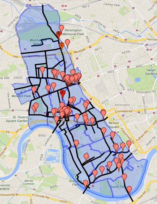
For the other key gyratories, junctions and roundabouts in the borough and beyond that need to be addressed, we shall continue to campaign. They range from the  pair at Shepherd’s Bush and Holland Park Roundabout to other junctions along the A4 and Westway to simpler T-junctions, crossroads and roundabouts.  The model of funding being adopted by TfL using major schemes and developer funding alongside cycle funding can be reused to help deal with these major junctions. We will start to make that case as part of our Space For Cycling campaign in the coming weeks.

We continue to study plans around the Flyunder and how in the longer term Hammersmith Broadway might return to two-way traffic and cease to be a gyratory. We hope to share more detail on this in the coming week.

London Cycle Grid – response from the West

We have earlier posted at length on the London Cycle Grid, here is our current proposed response which you are free to draw inspiration from. There have now also been responses from the Kensington and Chelsea group, on the London Cycle Campaign website and from Rachel Aldred which we reccomend you review. The deadline for the consultation is the 14th of February, but we’re not in love with what we’ve been given to respond to.

We are focussing our concerns on the lack of high quality East-West cycle routes. As we have shown already, there is much poorer linkage of the grid into West London than any other area. This appears to be the responsibility of the decisions made by Kensington and Chelsea in designing their section of the grid.

West London Combined Map

The grid linking into West London is shown above – as you can see the West London Line forms our Eastern boudnary and has very few good quality crossings for cyclists. Superhighway 9 would have provided a higher quality link on the main desire line. However, Superhighway 9 has not appeared on the Central London Grid, and is presumed to be cancelled. We find it simply deplorable that no-one has stood up and commented officially on its status before this consultation closes. The closest we have are the by now standard comments from Andrew Gilligan that:

On the dozen superhighway routes: as I’ve been saying for months, some of the routes proposed pre-Vision were on wholly unsuitable roads, or on roads where the local authority wasn’t comfortable with intervention to post-Vision standards. Those will be rerouted or cancelled, but there will be other entirely new routes to replace them. In other words, the number of routes will be (at least) the same, but they won’t be in the same places.

from the London Cycling Team Blog

We’re sorry Andrew, but it’s no comfort to cyclists who have issues with cycling on Hammersmith Road, Kensington High Street or Kensington Road that the 1 in a column for Superhighway 9 there is being added up somewhere else. More should be being done by the Mayor and TfL to examine how to make Kensington and Chelsea respond to the need for safer cycle routes in their streets. Encouraging people to cycle into London through a borough with no 20mph zones, no safe space for cycling on its main streets and the odd contraflow route here or there is not a viable strategy. It appears we are left to pray that the political will in Kensington and Chelsea – and it is that political choice, by the councillors of Kensington and Chelsea that is setting the agenda – changes.

With no clear indication of what happens. We must therefore consider out loud the possibilities:

If we take the grid as an indication, Superhighway 9 is gone and it is built somewhere else in London. There would therefore be no Superhighway between the Thames and the Westway. We count that there are at least 12,000 East-West cycle movements a day in this zone on main roads in official figures. That’s a lot of cyclists to try and focus onto 2-3 quiet road routes which don’t provide good mass cycling conditions.

Alternately it may be that Superhighway 9 is realigned along TfL roads rather than borough roads. This would presumably place it on the A4. This would link in somewhat with the proposed central london grid, but as Kensington and Chelsea’s feedback to their council has shown there are many gaps and round the houses routings in their grid which present serious issues.

Here is our response focussing on the issues we see most local to us.

[gview file=”http://hfcyclists.org.uk/wp/wp-content/uploads/2014/02/Final-hfcyclists-Cycle-Grid-Response.pdf”]

Hammersmith Grove – raised table

[osm_map lat=”51.498″ long=”-0.227″ zoom=”15″ width=”350″ height=”300″ marker=”51.49816,-0.22753″ marker_name=”bicycling.png” type=”CycleMap”]

We’ve received a brief proposal from Hammersmith and Fulham council for a raised table and the removal of an island in a zebra crossing on Hammersmith Grove. This is in response to problems with through vehicles – especially lengthy ones – regularly blocking this street. Though Hammersmith Grove is not a main road it is a designated C road and due to the configuration of nearby gyratories is used along with Trussley Road both for access to nearby homes and as a rat-run by many other motorists and taxis.

HammersmithGroveRaisedTableJan2014
This is the plan above from the council’s own PDF document.

Their accompanying letter has the following text

We propose to carry out highways improvements in Hammersmith Grove, between Amor Road and Trussley Road, following concerns raised by residents as well as observing frequent traffic conflicts along this section of road. Please see the plan overleaf.

As part of the proposal we will remove the existing traffic island at the zebra crossing to help facilitate traffic movements from Trussley Road. We will also raise the area in order to highlight the location of this crossing to approaching motorists and encourage lower speeds on their approach. We also plan to remove excessive and outdated street furniture around this location and plant more trees, in order to aesthetically improve this area and support the retail and restaurant environment. Some additional parking spaces will also be created.

We will aim to maintain access to the area throughout the works. Temporary diversions may be required during the works. Businesses and residents will be informed of any diversions in advance of them taking place.

We note the following issues:

  • This table will be placed on the main quiet road cycle route between Hammersmith and Brook Green (which avoids Shepherd’s Bush and Hammersmith gyratories). As such the route must be safe for small children who are often seen cycling through the area accompanied and it presents a barrier to some already. The ramps will be a particular problem for them.
  • This follows a recent consultation on a neighbourhood scheme on the other side of Trussley Road – a more rounded plan needs to be made about dealing with through traffic, rather than two disjoined schemes.
  • With the removal of the width restriction at the zebra crossing vehicle speeds may increase, at present the zebra island helps slow vehicles prior to the turn many vehicles perform to enter Trussley Road
  • Kerb heights vary from around 10-15cm in the area
  • The raised table is quite short and does not extend sufficiently into the side streets to be of use to pedestrians
  • Ramps are of varying length on the side and main streets. All have the same speed limit of 20mph, so surely need similar approaches
  • Car parking is being extended onto the ramps
  • There is no improvement to cycle parking in an area with a severe lack of it, this is a good location to experiment with cycle parking in the carriageway.

[gview file=”http://hfcyclists.org.uk/wp/wp-content/uploads/2014/02/hfcyclists-Hammersmith-Grove-Table.pdf”]

Space For Cycling – agenda by Ward and Theme

Our meeting to discuss and define one ask per ward for the Space for Cycling campaign is on Monday 17th February upstairs in local pub, Blue Anchor at 13, Lower Mall, Hammersmith, W6 9DJ from 6:30PM, starting just after 7PM.

Ahead of the meeting, and after our earlier summary we now have a new, more colourful and comprehensive map of responses to our survey. We will add to this with a detailed tabular list of all asks in each ward and submitted suggestions ahead of the meeting. Naturally any extra asks are still welcome in comments here or at the meeting itself. If you can’t make the meeting comment below or send comments to spaceforcycling@hfcyclists.org.uk – Thanks!

We’d encourage everyone to explore the asks by reading over our summary and looking at the map ahead of the meeting. We will be working from printouts on the night but will have a computer or two should we need to refer to any data in detail. Our aim is to pick one theme per ward and a simple, clear idea of the aim to achieve with it. We can combine multiple ideas into a single ask, which will be particularly necessary in wards like Hammersmith Broadway.

Load the map in a new window or tab by clicking here then read our quick guide:

You can turn layers for each of the asks on and off on the map, along with the ward boundaries.
You can switch between a cycle base map or a minimal black and white map. You can also turn layers for each of the asks on and off on the map, along with the ward boundaries using the control top-right, it is collapse by default and expands when highlighted.

Clicking on a coloured section of road explains the ask, says how many supported it and confirms the road name.

Clicking anywhere else inside a ward will confirm the name of the ward.

We will split the agenda and the borough into three distinct sections. Each of these are a combination of wards, to enable us to discuss the themes, and how they might best be applied in a coherent area. We may change the order in a cluster as we progress but should stick to the otherwise.

These ward groups are from the north of the borough to the south with each a cluster of wards around the three major town centres of the borough – Shepherd’s Bush, Hammersmith and Fulham.

Shepherd’s Bush Cluster

Screen Shot 2014-02-10 at 20.05.46

College Park and Old Oak Ward

Protected space on main roads – Wood Lane, Scrubs Lane, Du Cane Road, Old Oak Common Lane

Greenways – routes on Wormwood Scrubs and along the Grand Union Canal.

Wormholt and White City Ward

Areas without through motor traffic – Wormholt Park Area – highlighted Adelaide Grove, Galloway Road and Wormholt Road on the map.

Protected space on main roads – A40 / Du Cane Road Crossroad

Shepherd’s Bush Green Ward

Protected space on main roads – Shepherd’s Bush Green, Uxbridge Road, Westfield Shopping Centre approaches and Holland Park Roundabout

Safe routes to schools – Uxbridge Road

Liveable Town Centres – Shepherd’s Bush Green

Askew Ward

Safe routes to schools – Goldhawk Road (concern noted on speed)

Protected space on main roads – Goldhawk Road

Hammersmith Cluster

Screen Shot 2014-02-10 at 20.06.04

Addison Ward

Areas without through motor traffic  – Trussley Road and associated backstreets (Hammersmith Grove, Sulgrave Road, Lena Gardens, Batoum Gardens)

Ravenscourt Park Ward

Protected space on main roads – King Street continuing to Chiswick High Road and Goldhawk Road

Liveable town centres – King Street

Areas without through motor traffic  – Ashchurch Park Villas

Hammersmith Broadway Ward

Protected space on main roads – Hammersmith Broadway Gyratory, Hammersmith Bridge, A4 to Knightsbridge, King Street Cycle Lane (extend to Broadway), Entry & exit from Hammersmith Broadway to Shepherds Bush Road, Entry from Beadon Road, Glenthorne Road, Dalling Road, Studland Street, Entry Exit from Hammersmith Broadway to Queen Caroline Street, Blacks Road as alternative to Hammersmith Bridge Road.

20mph – Hammersmith Bridge

Greenways – Cycle routes not continuous along Thames

Liveable Town Centres – Hammersmith Broadway, King Street

Safe Routes To Schools – Hammersmith Flyover

Avonmore and Brook Green Ward

 Safe Routes to Schools – Brook Green

Areas Without Through Motor Traffic – Brook Green

Fulham Cluster

Screen Shot 2014-02-10 at 20.06.11

20mph – One person suggested 20mph throughout the SW6 postcode. We’ve mapped what this would mean, and it clearly leads to the question of a borough wide limit. There are rather more 20mph zones in the north of the borough, though no coherent map of current 20mph roads exists (that we’ve found). SW6 covers roads in all of the following wards.

Fulham Reach Ward

Protected Space on Main Roads – Fulham Palace Road, exit of St Dunstan’s Road

Areas Without Through Motor Traffic – Margravine Gardens

North End Ward

Protected space on main roads – Junction of Gliddon Road and A4.

Areas without through motor traffic – Barons Court square mile, Barton Road, Palliser Road, Vereker Road, Baron’s Court Road

Fulham Broadway Ward

Areas without through motor traffic – Ongar Road / Walham Grove / Halford Road

Munster Ward

20mph speed limits – Gowan Avenue, Bishops Road, Wardo Avenue

Town Ward

Protected space on main roads – New King’s Road (tough noted as busy and narrow)

Parsons Green and Walham Ward

Areas without through motor traffic – Effie Road no contraflow 1-way street and rat run, close Parsons Green on side by White Horse Pub – due to speeding and excess traffic near school.

Liveable town centres – Fulham Broadway

Protected space on main roads – Wandsworth Bridge Road (detailed proposal for a bidirectional cycle lane), King’s Road, New King’s Road, Fulham Road, A308 Sloane Square to Putney Bridge.

Sands End Ward

Protected space on main roads – Wandsworth Bridge Road

Palace Riverside Ward

Protected space on main roads – Fulham Palace Road, Putney Bridge and approaches

Central London Cycle Grid

Transport for London have now published a complete draft plan for  Central London Cycle Grid. This initiative follows many years of the London Cycle Campaign demanding a grid of cycle routes in central London.

The need for a grid is clear to anyone who regularly or even occasionally cycles in London and simply aims to get between any two points within it. The routes are complex, often of poor quality and rarely joined up. So, we have a network proposed, of superhighways (in blue) and quietways (in purple). Broadly speaking the idea is that superhighways are on main roads and involve more seperation from traffic, whereas quietways are in quieter areas. Except of course, where a quietway crosses a busy road or a superhighway is routed away from a major road. The quietways will be using bollards and other measure to help reduce some through motor traffic, and naturally will be more sophisticated than merely closing whole roads with posts. All modes should retain access but the route for that access may change. Broadly speaking the accompanying strategy is at least aware of these issues, and probably the main issue with this grid is about density and coverage.

Here are a few images to give an idea of the level of change and intervention envisaged to make these routes work.

Example of Superhighway (blue routes)

There is only one example of a superhighway in the document which is the new North-South Superhighway:

An example of segregation that could be used on Kensington High Street - at risk due to the council objecting
An example of a superhighway as Transport for London now envisages them

This is quite a change from how this road looks today:

TfL image of
TfL image of the same road above today, taken from the Cycling Vision video
Examples of Quietways (purple routes)

For quietways, use is made of photos of a couple of existing routes. There are no mock ups used, so harder to compare before and after.

Goldsmiths Row in Hackney, one cited example of a quietway. Through motor traffic is blocked by bollards.

There is a before shot of Goldsmiths Row on Hackney Cyclists blog (not the local campaign, but a local blogger) if you’d like to compare. Note that as to the rest of that blog, it’s worth reading Buffalo Bill’s comments on Goldsmiths Row for another local view on some of the issues raised about bollards versus segregation in the whole piece. These issues are important to the idea of the cycle grid. There are places where cycling can be given a good through route with bollards and paint it may make for higher capacity and better conditions than segregation. No one tool will work everywhere.

Black Friars Lane, City of London - another example of a quietway cited.
Black Friars Lane, City of London – another example of a quietway cited. Again, bollards mean only cycles can use it as a through route.

For full details of the current thinking about execution it is best currently to refer to the full PDF on the Central London Grid written by Transport for London (5.6MB) and the TfL video on the Mayor’s wider Cycling Vision (5:25 long). In a few weeks/months we should also see the new London Cycle Design Standards which will give more detail. If you’re very curious the Nine Elms Cycle Strategy draft gives a nice preview of the current thinking applied to a complete area of London.

central-london-grid-map-with-borough-boundaries
TfL’s map of the Central London Grid with borough boundaries. The bulk is in Westminster but as can be seen it covers 8 boroughs in all.

None of the Central London Cycle Grid is in Hammersmith and Fulham but elements of it reach towards our borough. More importantly there is a lot of concern to be expressed at what is not on the map. There is no Cycle Superhighway 9. It is either cancelled, or off the table at present. If you’re wondering why, you might want to look at what Kensington and Chelsea are proposing in the area of Kensington High Street…

Screen Shot 2014-01-06 at 18.04.09

…basically, nothing. Superhighways are marked in blue. You can see there aren’t any. On the map you can see the wide main roads in Kensington and Chelsea, both High Street Kensington and the A4 in white with almost nothing happening to them. The network in purple are the new quietways. It way be that these can use some quiet streets and make successful routes, but not east west as clearly Holland Park have refused cycling through their green space! We know that such things can work on the continent and we know that they can work in Hackney.  What’s wrong with West London? We are also puzzled by the quietway that appears to be on the A4 just to the left of the text saying Earls Court.

Now, that’s not to say that there won’t be any superhighway reaching Hammersmith at all. No, thanks to TfL we do get a new East-West route along the Westway. You can see this blue route escaping from Hyde Park then jumping onto the Westway somewhere near Royal Oak. Given that this will be some distance up in the air, it will be of little benefit for local journeys in the area between White City and Paddington, unless a lot of ramps are provided. This superhighway, known also as Cycle Crossrail does have many merits on its own, but it is not enough for the whole of West London. There is no other superhighway planned between it and the Thames.

Screen Shot 2014-01-06 at 18.03.49

We have been informally discussing this issue with local officers for some time. It would be best if Cycle Superhighway 9 were built, and improvements were made to Kensington High Street. Not all is lost without it, and indeed we know that Hammersmith Broadway is set to be reviewed perhaps as a replacement for Superhighway 9 addressing some of the issues there. However, there is no plan within Hammersmith for addressing any shift that might occur from people altering routes to utilise the new Cycle Crossrail Superhighway.

central-london-grid

This is just a quick overview of the Central London Grid. We continue to review the proposals and will make our response in due course. We encourage further discussion here and elsewhere and hope many others will respond to the consultation. The closing date is 14th February 2014, and we’d like to see proposals we can love and will genuinely change the culture of cycling in all of London. As it stands, West London is not seeing the changes or benefits it should, and the gap is political will in boroughs like Kensington and Chelsea.

central-london-grid-map

Update  – Joining the Central London Grid up to Outer London

As we made clear when we first wrote this, a key concern for us was how the new grid of cycle routes in Central London would join up with existing routes in Hammersmith and Fulham. Well, we’ve now had a go at looking at that. And we’ve had a look at how things are on the East side of town to compare.

West London Combined Map
LBHF existing routes on the left, new Cycle Grid on the right, click through for full size

As you can see, none of the new routes proposed in Kensington and Chelsea link to any existing East-West route. It is plausible that new routes will be made in Hammersmith to join them, but it means a number of routes sensibly placed on main roads in Hammersmith will continue to stop at the borough boundary.

East London Combined Map
new Cycle Grid on the left, with existing routes in Islington, Hackney and Tower Hamlets linking in, click through for full size

Somehow East London has less of this problem, you can easily see how the Central London grid will link into their boroughs.

Now, if you’d also like to explore these issues yourself, we have a few tools to share. We’ve used Google Earth to make the maps above (along with some neat cropping in some image software). So, in addition to the TfL hosted details on the Central London Grid (which we urge you to look at first) you can also install Google Earth, then download our ‘kmz’ file of the Central London Grid and add it to your map (File–> Open in the Google Earth app). You can also add OpenCycleMap to Google Earth using the files at this site (free registration necessary).

All of this lets you look at the Central London Grid as an overlay and explore on Google Street View. Which obviously means we have yet more to report and that will probably go into a different post.

Space4Cycling – survey responses

Towards the end of 2013 we asked you for your feedback on barriers to cycling in Hammersmith and Fulham and beyond. We are delighted with the level of responses we’ve had and have had plenty of data to review over Christmas and New Year.

We’re still examining the issues in each ward but already have been able to produce a map of responses and potential improvements.

Space4Cycling working map


There are obvious clusters at Hammersmith Broadway and Shepherd’s Bush Green, where gyratories present a barrier to many. Additionally you can see repeated patterns along many key routes, highlighting the lack of provision on East-West routes that many use for commuting.

We have highlighted in black the roads where interventions have been suggested by the survey data. These actually form a reasonable basic grid, though the gaps in Fulham and elsewhere need to be addressed.

Please explore the map and let us know by comment or email if you’ve anything you’d like to see added.

If you’re wondering how we put the map together, we’ve also written that up.